
|
|
||
|
|
|
|
Great Circle SailingBelow is a form using JavaScript that solves the Great Circle Sailing problem: Great CircleA great circle is defined as a circle on the earth's surface the plane of which passes through the centre of the earth. For navigation purposes :
Great Circle SailingTo follow a great circle track, the navigator needs to adjust the ship's course continuously because the great circle track is a curve when plotted on a Mercator Chart. Therefore, it is not really practicable to sail on an exact great circle route. In order to take advantage of the shorter steaming distance of the great circle track, mariners usually divide a great circle track between the initial position and the destination into smaller segments (way points) of about one to two day's steaming time and make course adjustments at noon. The total distance is therefore the sum of the distances of those segments calculated by means of Mercator Sailing. Composite Great Circle SailingAlthough the great circle track is the shortest route between two locations, it also usually enroutes closer to the pole (or to higher latitude) than the two places.
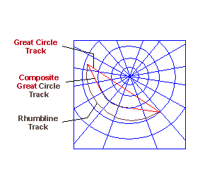
The easiest method to outline a composite greate circle route is by plotting it on a Gnomonic chart. The figure on the right shows the relationship between the three types of route, the rhumb line, the great circle and the composite great circle routes for the same set of locations. What's new here?The most annoying part of the great circle sailing calculation is to find out the way points along the great circle route. The traditional way is to determine the position of the vertex and use Napier's rules to calculate individual way point's Latitude and Longitude. This method is not really very complex but is not suitable for computerization as a set of conditions will need to be established in order to determine the side of the positions. In this script, the formula uses a simple sine relationship between Latitude and Logitude which makes the way point calculation more suitable for computerization. The formula is :-tan Latitude = sin (Longitude - X) * tan K where X is the Longitude when the GC track crosses the equator from south to north and K is the maximum Latitude of the GC track or Latitude of Vertex. The Longitude value should be reduced to 360-degree notation measured from Greenwich towards the East, e.g. 165 degrees West will be treat as 195 degrees. By using the above formula, this script provides a full definition of great circle tracks at 5-degree longitude intervals - the [Full Track] function of the form - as well as the corresponding Latitude of any given Longitude.
|
|
|
|
Europe: Port Aleria, Rosnakilly, Kilmeena, Westport, Co. Mayo, Ireland - USA: PO Box 726, Mahwah, NJ 07430 All content on this site is subject to Copyright© - All rights reserved. Contact us - Advertising - Privacy - Terms & Conditions - Copyright & Trademark - Webmaster |
 To avoid the danger of sailing high latitude, which is normally associated with bad weather and icing, a careful master mariner will normally set a latitude limit on his ocean passage plan. The ocean passage will thus consist of a first great circle track with vertex at the latitude limit then sailing along that latitude until meeting the vertex of a second great circle track leading to the destination. This type of route is named as composite great circle route.